


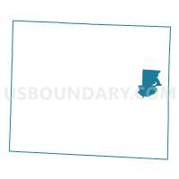
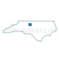
Voting District RC1, Guilford County, North Carolina
About
Outline

Summary
| Unique Area Identifier | 640260 |
| Name | Voting District RC1 |
| County | Guilford County |
| State | North Carolina |
| Area (square miles) | 12.16 |
| Land Area (square miles) | 11.97 |
| Water Area (square miles) | 0.19 |
| % of Land Area | 98.43 |
| % of Water Area | 1.57 |
| Latitude of the Internal Point | 36.09914370 |
| Longtitude of the Internal Point | -79.60980560 |
Maps

Graphs
Select a template below for downloading or customizing gragh for Voting District RC1, Guilford County, North Carolina


Neighbors
Neighoring Voting District (by Name) Neighboring Voting District on the Map
- Voting District GIB, Guilford County, NC
- Voting District JEF1, Guilford County, NC
- Voting District JEF2, Guilford County, NC
- Voting District RC2, Guilford County, NC
- Voting District SWASH, Guilford County, NC
Top 10 Neighboring County Subdivision (by Population) Neighboring County Subdivision on the Map
- Rock Creek township, Guilford County, NC (11,635)
- Jefferson township, Guilford County, NC (10,424)
- Washington township, Guilford County, NC (2,937)